SOUTH AEGEAN VOLCANIC ARC   
South Aegean Volcanic Arc, Greece
The South Aegean Volcanic Arc (herein SAVA) is a chain of volcanic centers in the south Aegean Sea that is characterized both by subaerial and submarine volcanism.

In the broader region of Eastern Mediterranean and the Aegean Sea, the most prominent geodynamic event currently taking place is the subduction of the African Lithospheric Plate beneath the Eurasian Lithospheric Plate. According to extensive scientific studies, this plate convergence is occurring at a rate of approximately 35mm each year, while Africa bends below Europe in a northward direction. As a result, the rocks of the two plates experience extreme temperatures and pressures at great depths below the surface, hence leading to their extensive melting and the production of magma. Some volumes of this magma remain deep within the lithosphere, while others ascend to the surface and erupt, giving birth to volcanoes.

The manifestation of active volcanism in the South Aegean takes place approximately 250km north of the plate convergent boundary.  The result is the worldwide known South Aegean Volcanic Arc, a chain of volcanoes that is approximately 600km long with a width of 20-40km and extends from the Saronic Gulf in the west to the islands of Kos and Nisyros in the east. It consists of the volcanic centers of Sousaki-Methana, Milos-Antimilos, Christiana-Santorini and the Kos-Yali-Nisyros volcanic field, as well as a number of offshore volcanic structures (like Kolumbo volcano, 7 Km NE of Santorini) that were detected after extensive and systematic reconnaissance of the Aegean Sea floor . The volcanic arc has been active for the past 4.7 million years. However, today only the volcanoes of Methana, Santorini, Kolumbo and Nisyros remain active but are in a dormant state according to scientists.

   MINOAN ERUPTION   
The last destructive volcanic eruption of Santorini
The Late Bronze Age eruption, also known as the “Minoan” eruption (1613-1620 BC) was one of the largest volcanic eruptions in human history.

The ‘Minoan’ eruption was the last destructive eruption of Santorini. In a matter of hours to days, the volcano discharged several tens of km3 of gas-charged magma which entered the sea as pyroclastic flows and rock debris. Large quantities of pyroclastic products (tephra and aerosols) ejected many kilometers to the atmosphere and blanketed the prehistoric town of Akrotiri and in a matter of hours the whole east Mediterranean region. The following tsunami traveled as far as the northern coast of Crete having at least 9 m height and together with the atmospheric effects may have contributed to the decline of the great Minoan civilization, the dominant civilization in the Mediterranean at the time. According to scientific studies, the eruption ranks as one of the largest of the last 10,000 years and was responsible for the present-day morphology of the island.

Modern volcanological and archaeological research, through detailed studies of the deposits of pumice, ash and marine sediments on the Aegean islands and across the Eastern Mediterranean and studies on the remains of the Minoan culture, shed light on the chronicle of the Minoan eruption. There is a consensus that the eruption occurred in four phases with an initial precursory phase. Every phase was characterized by destructive events and violent phreatomagmatic explosions which culminated in the formation of the 11x7km present-day caldera.

Old map of Santorini
Map of Santorini island of 1848, illustrating the morphology of the caldera and the Kameni islands
   KAMENI ISLANDS    
Kameni Islands
Creation

The historical eruptions of Palea and Nea Kameni shaped the morphology of the present-day volcano inside the unique flooded caldera of Santorini.

The Kameni islands are the subaerial expression of a 4.3 ± 0.7 km

3

lava shield, 3.5 km in basal diameter, the summit of which towers 470 m above the caldera seafloor. The magmatic vents of both islands lie within a NE-SW volcanotectonic line (known as the Kameni line) which controls the magma ascent of the region. Geochemical and mineralogical studies have revealed that actual morphology of the Kameni islands have been defined by nine subaerial eruptions: 197 BC, AD 46-47, AD 726, 1570/1573, 1707-1711, 1866-70, 1925-28, 1939-41, and 1950. Every eruptive event discharged dacitic lava flows and formed lava domes, channels and levees, blocky lavas, ash plumes, ballistic ejecta and pillow lavas below the water surface.

Today, the volcano is continuously monitored by a network of instruments that measure seismicity, ground movements, temperature and the chemistry of hot springs.

National Geological Park
of Nea Kameni Volcano
Nine episodes timeline
The below timeline of the nine volcanic episodes illustrates
in detail the creation and evolution of Palea and Nea Kameni
islands through the centuries.

197 B.C.

46-47 A.D.

726

1570-1573

1701-1711

1866-1870

1925-1928

1939-1941

1950

Santorini
Volcano App
Santorini island is one of the most exquisite volcanic landscapes in the world, featuring an iconic caldera in the center of which the volcanic islands of Palea and Nea Kameni are located.
The Santorini Volcano App allows users to virtually explore the most significant points of interest of the island, learn about the historic Minoan Eruption, navigate to the volcanic path of Nea Kameni island and learn the rich history of the volcano. The users can also admire unique photographic material, including high quality photos, 360 degrees panoramas and videos of interesting volcanic points. Easy to use, this complete virtual informational guide will bring Santorini and Nea Kameni to the visitor’s fingers.
Explore the secrets of one of the youngest volcanoes in the Mediterranean

Palea and Nea Kameni islands are a wondrous natural laboratory and are included in the Natura 2000 European network of protected areas.

Getting To
Nea Kameni Island
The volcanic island of Nea Kameni is easily accessible from the ports of Santorini, on a daily basis.
Nea Kameni is a volcanic island that offers a variety of experiences to the visitors, from exploring the unique volcanic formations and craters to enjoying breathtaking views of Santorini and the caldera. It is suitable for a one-day excursion from Santorini.

Daily boat tours are organized especially during the summer months, departing from 2: the Old Port of Fira (Gialos),
3: Athinios Ferry Port (the new port), 4: Ammoudi (Oia) or from 5: Vlychada at the southern part of the island. The trip from the old and the new port usually takes about 20 and 30 minutes respectively. An important number of travel agencies commonly offer packages that include not only a visit to Nea Kameni, but also an extended intra-caldera cruise that also takes visitors to Palea Kameni thermal waters, the island of Therasia and a sail close to the caldera walls.
  1. Nea Kameni
  2. Fira old harbor
  3. Athinios Ferry port
  4. Ammoudi
  5. Vlychada
Nea Kameni
Fira old harbor
Athinios Ferry port
Ammoudi
Vlychada
   SAFETY TIPS   
Useful Phone Numbers
Management Body: +30 22860 23021


Santorini General Hospital: +30 22860 10021


Emergency Police Number: 100


Fire Brigade: 199


European Emergency Number: 112


Volcano
Safety Tips
Please respect this unique environment!
Help preserve this physical laboratory!
  • Stay on established walkways for your safety and to protect the physical environment and fragile formations. Unstable ground in places.
  • Follow the information on the signs. Never enter into the craters. Danger of rockfalls and volcanic gases.
  • Never remove or detach the rocks. 
  • Appropriate clothing, sport shoes, sun protection, hat and water are highly recommended.
  • Any rubbish should be discarded directly in the designated bins. 
  • Keep away from the instruments of the monitoring network set up on the island.
  • Supervise children at all times.
  • Observe safe distances and settings for selfies.
  • In case of an organized tour, please follow the instructions of your guides.
GEOTHIRA is responsible for the protection
and the management of the volcano.

About this
Research Program

A digital guide mobile application that improves the services of the National Geological Park of Nea Kameni Volcano

The scientific project concerning the production of a mobile application for smart devices in order to showcase the geological volcanic path of Nea Kameni and the points of interest. The content involves photographic and video material, historical records of volcanic eruptions, thematic Digital Elevation Models (DEM), volcanological map of Palea Kameni and Nea Kameni with the points of interest (POI), digital maps of the lava flows and the elevation phases of Kameni islands from 197 BC to 1950 AD based on scientific data and an enlightening, descriptive text.

Moreover, the application is promoted through a corresponding website and a modern tourist leaflet for the volcano.

The application has been developed under the guidance of the Laboratory of Physical Geography of National and Kapodistrian University of Athens (NKUA).

Project
1.       NATIONAL AND KAPODISTRIAN UNIVERSITY OF ATHENS
           LABORATORY OF PHYSICAL GEOGRAPHY
2.      THIRA MUNICIPALITY
3.      GEOTHIRA

Paraskevi Nomikou, Associate Professor (Laboratory of Physical Geography, NKUA), Scientific Coordinator – Geoscientist of Santorini

Varvara Antoniou
Educational Research Staff | Faculty of Geology and Geoenvronment | National and Kapodistrian University of Athens Dr Geosciences | Natural Disasters – Geographic Information Systems

Stavroula Kazana, PhDc. Geologist – Engineering Geologist

Pavlos Krassakis, PhDc. Geologist – GIS specialist

Kyriaki Drymoni, Dr. Geologist

Joseph Perros, PhDc. Historian

Special thanks to Prof. Tim Druitt,
(Univ. of Clermont) for his help on the scientific text

With the contribution of:


GEOTHIRA

George Pehlivanides hands-on.studio
Research & Art Direction, Branding, UX/UI Design, Project Management

EContent Systems
Web-Mobile-Digital Marketing Services
econtentsys.gr
Project Management: Aristides Batis
Mobile Development: Agiomavritis Marios
Web Development: Elmousian George

Paraskevi Nomikou

Artemia Argirou

Artemis Tomai

Alexandros Arapantonis

Joseph Perros

Stavroula Kazana

ETH Zurich https://ba.e-pics.ethz.ch/main/galleryview/qsr=Santorin%201925 (Copyright notice: ETH-Bibliothek Zurich, Bildarchiv/Fotograf:Wehli, Leo/Dia_247-11130/CC BY-SA 4.0)

GAPfilmingteam, George Petropoulos, Andreas Petropoulos

Bruins, H. J., MacGillivray, J.A., Synolakis, C.E., Benjamini, C., Keller, J., Kisch, H. J., Kleugel, A., van der Plicht, J & Klugel, A. (2008). Geoarchaeological tsunami deposits at Palaikastro (Crete) and the Late Minoan IA eruption of Santorini., J. Arch. Sci. 35, 191–212.

Cadoux, A., Scaillet, B., Bekki , S.,Oppenheimer , C. & Druitt, T.H. (2015). Stratospheric Ozone destruction by the Bronze-Age Minoan eruption (Santorini Volcano,Greece), Scientific Reports, 5.

Druitt, T.H., Mellors, R.A., Pyle, D.M., and Sparks, R.S.J., (1989). Explosive volcanism on Santorini, Greece: Geological Magazine, v. 126, p. 95–126.

Druitt, T. H, Edwards L., Mellors R.M., Pyle D.M, Sparks R.S.J., Lanphere M., Davies M., & Barreirio, B. (1999). Santorini volcano, Geological Society Memoir. J. Geol. Soc.Lond. 19, 165.

Druitt, T. H. (2014). New insights into the initiation and venting of the Bronze-Age eruption of Santorini (Greece), from component analysis, Bull. Volcanol. 76, 794.

Druitt, T.H., Francalanci, L. & Fabbro, G. (2015). Field guide to Santorini Volcano, MeMoVolc short course, Santorini.

Druitt, T.H., McCoy, F.W., Vougioukalakis, G.E. (2019). The Late Bronze Age Eruption of Santorini Volcano and Its Impact on the Ancient Mediterranean World, Elements, 15 (3): 185–190.

Evans, K.J., McCoy, F. (2020). Precursory eruptive activity and implied cultural responses to the Late Bronze Age (LBA) eruption of Thera (Santorini, Greece). J. Volcanol. Geotherm. Res. https://doi.org/10.1016/j.jvolgeores.2020.106868.

Fouqué, F. (1999). Santorini and its eruptions, Translated and annotated by McBirney A.R., The Johns Hopkins Press, Baltimore.

Fouqué, F., (1879). Santorin et ses éruptions: Paris, Masson et Compagnie, 440 p. (in French).

Friedrich, W., Kromer, B., Friedrich, M., Heinemeier, J., Pfeiffer, T., Talamo, S. (2006). Santorini eruption radiocarbon dated to 1627–1600 Bc., Science 312, 548.

Fytikas, M., Kolios, N., and Vougioukalakis, G., (1990) PostMinoan activity of the Santorini volcano: Volcanic hazard and risk, forecasting possibilities, in Hardy, D.A., Keller, J., Galanopoulos, V.P., Flemming, N.C., and Druitt, T.H., eds., Thera and the Aegean world III, v. 2: London, The Thera Foundation, p. 183–198.

Georgalas, G.C., (1953). L’éruption du volcan de Santorin en 1950: Bulletin Volcanologique, ser. II, v. 13, p. 39–55.

Georgalas, G.C., (1962). Catalogue of the active volcanoes and solfatara fi elds of Greece: Rome, International Association of Volcanology, v. 12, p. 14–29.

Georgalas, G., and Liatsikas, N., (1925a). Sur la nouvelle éruption du volcan de Santorin (août 1925): Comptes Rendus Hebdomadaires des Seances de l’Academie des Sciences, v. 181, p. 425–427.

Georgalas, G., and Liatsikas, N., (1925b). Sur la nouvelle éruption du volcan de Santorin (1925): Comptes Rendus Hebdomadaires des Seances de l’Academie des Sciences, v. 181, p. 1147–1149.

Georgalas, G., and Liatsikas, N., (1936a). Die historische Entwickelung des Dafni-Ausbruches 1925–1926, in Reck, H., ed., Santorin: v. 2: Berlin, Dietrich Reimer, p. 1–96 (in German).

Georgalas, G., and Liatsikas, N., (1936b). Der Nautilus Ausbruch, in Reck, H., ed., Santorin: v. 2: Berlin, Dietrich Reimer, p. 328–340 (in German).

Georgalas, G.C., and Papastamatiou, J., (1951). Uber den Ausbruch des Santorinvulkanes von 1939–1941. Der Kténas Ausbruch: Bulletin Volcanologique, v. 11, p. 1–37.

Georgalas, G.C., and Papastamatiou, J., (1953). L’éruption du volcan de Santorin en 1939–1941. L’éruption du dome Fouqué: Bulletin Volcanologique, v. 13, p. 1–38.

Goree, F., (1710). A relation of a new island, which was raised up from the bottom of the sea on the 23d of May 1707, in the Bay of Santorin, in the Archipelago: Philosophical Transactions of the Royal Society of London, v. 27, p. 354–375.

Heiken, G., McCoy, F. (1990). Precursory activity to the Minoan eruption, Thera, Greece, In: Hardy DA (ed.) Thera and the AegeanWorld III, vol 2. Thera Foundation, London, pp 13–18.

Hooft, E.E.E., Heath, B.A., Toomey, D.R., Paulatto, M., Papazachos, C.B., Nomikou, P., Morgan, J.V., Warner, M.R. (2019). Seismic imaging of Santorini: Subsurface constraints on caldera collapse and present-day magma recharge, Earth and Planetary Science Letters, 514, 48-61, ISSN 0012-821X, https://doi.org/10.1016/j.epsl.2019.02.033.

Johnston, E. N., Sparks, R.S.J., Phillips, J.C. & Carey, S. (2014). Revised estimates for the volume of the Late Bronze Age Minoan eruption, Santorini. Greece, J. Geol. Soc. Lond. 171, 583–590.

Karátson, D., Telbisz, T., Gertisser, R., Strasser, T., Nomikou, P., Druitt, T., Vereb, V., Quidelleur, X., Kósik, S. (2020). Constraining the landscape of Late Bronze Age Santorini prior to the Minoan eruption: Insights from volcanological, geomorphological and archaeological findings, Journal of Volcanology and Geothermal Research, 106911, 104, ISSN 0377-0273, https://doi.org/10.1016/j.jvolgeores.2020.106911.

Karátson, D., Gertisser, R.,Telbisz, T., Vereb, V., Quidelleur, X.,Druitt, T.H., Nomikou, P. & Kósik, S. (2018). Towards reconstruction of the lost Late Bronze Age intra-caldera island of Santorini, Greece, Scientific Reports volume 8.

Karátson, D., Telbisz, T., Gertisser, R., Strasser, T., Nomikou, P., Druitt, T., Vereb, V., Quidelleur, X., Kósik, S. (2020). Constraining the landscape of Late Bronze Age Santorini prior to the Minoan eruption: Insights from volcanological, geomorphological and archaeological findings, Journal of Volcanology and Geothermal Research, Volume 401, https://doi.org/10.1016/j.jvolgeores.2020.106911.

Kténas, C.A., (1925a). L’éruption du volcan de Santorin: Comptes Rendus Hebdomadaires des Seances de l’Academie des Sciences, v. 181, p. 376–377.

Kténas, C.A., (1925b). L’éruption du volcan de Santorin. Caractères morphologiques: Comptes Rendus Hebdomadaires des Seances de l’Academie des Sciences, v. 181, p. 518–520.

Kténas, C.A., (1925c). Les phénomènes explosifs de l’éruption du volcan de Santorin: Comptes Rendus Hebdomadaires des Seances de l’Academie des Sciences, v. 181, p. 563–565.

Kténas, C.A., (1926). L’éruption du volcan des Kaménis (Santorin) en 1925. Part I: Bulletin Volcanologique, v. 7–8, p. 3–64.

Kténas, C.A., (1927). L’éruption du volcan des Kaménis (Santorin) en 1925. Part II: Bulletin Volcanologique, v. 11–12, p. 7–49.

Kténas, C.A., and Kokkoros, P., (1929). Le dôme parasitaire de 1928 et l’évolution du volcan des Kaménis (Santorin): Bulletin Volcanologique, v. 19–22, p. 87–97.

Manning, S.W., Ramsey, C.B., Kutschera, W., Higham, T., Kromer, B., Steier, P., Wild, E.M. (2006). Chronology for the Aegean Late Bronze Age 1700–1400 B.C., Science 312, 565–569.

McCoy, F. & Heiken, G. (2000). Tsunami generated by the Late Bronze Age eruption of Thera (Santorini), Greece, Pure Appl. Geophys., 157, 1227–1256.

McVey, B.G., Hooft, E.E.E., Heath, B.A., Toomey, D.R., Paulatto, M., Morgan, J.V., Nomikou, P. Papazachos, C.B. (2020). Magma accumulation beneath Santorini volcano, Greece, from P-wave tomography, Geology, 48 (3): 231–235, doi: https://doi.org/10.1130/G47127.1

Nomikou, P., Papanikolaou, D., Alexandri, M., Sakellariou, D., Rousakis, G. (2013). Submarine volcanoes along the Aegean volcanic arc, Tectonophysics 597-598: 123-146

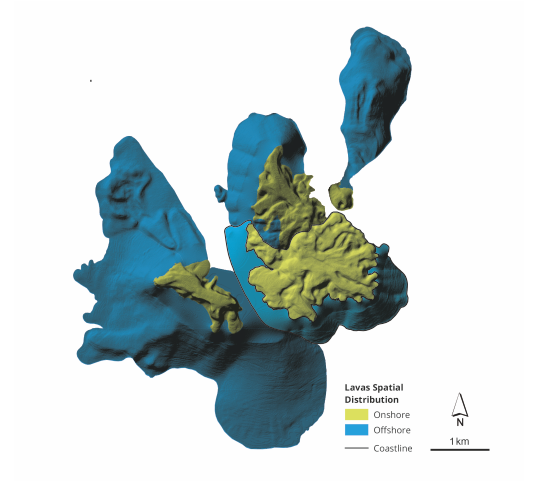
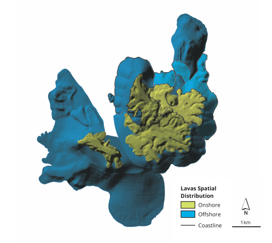
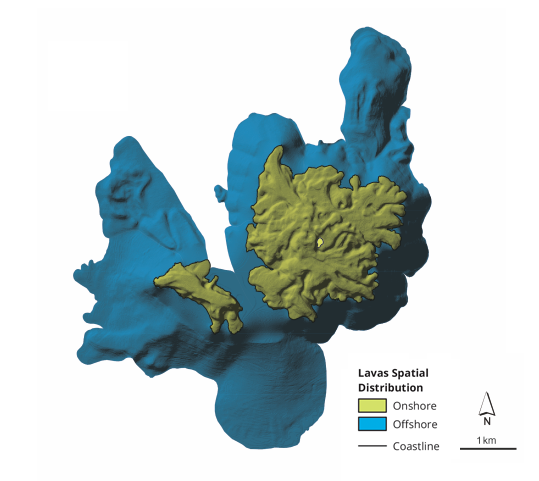
Nomikou, P., Parks, M.M., Papanikolaou, D., Pyle, D.M., Mather, T.A., Carey, S., Watts, A.B., Paulatto, M., Kalnins, M.L., Livanos, I., Bejelou, K., Simou, E., Perros, I. (2014). The emergence and growth of a submarine volcano: the Kameni islands, Santorini (Greece), Geo. Res. J. 1–2, 8–18.

Nomikou, P., Druitt, T. H., Hübscher, C., Mather, T.A, Paulatto, M., Kalnins, L.M., Kelfoun, K., Papanikolaou, D., Bejelou, K., Lampridou, D., Pyle, D.M., Carey, S., Watts A.B, Weiß, B. & Parks, M.M. (2016). Post-eruptive flooding of Santorini caldera and implications for tsunami generation. Nat Commun 7, 13332

Nomikou, P., Hübscher, H., Carey, S. (2019). The Christiana–Santorini–Kolumbo Volcanic Field. Elements; 15 (3): 171–176

Novikova, T., Papadopoulos, G. & Mccoy Fw. (2011). Modelling of tsunami generated by the giant Late Bronze Age eruption of Thera, South Aegean Sea, Greece. Geophysical Journal International – GEOPHYS J INT. 186. 665-680. 10.1111/j.1365-246X.2011.05062.x.

Parks, M.M., Biggs, J., England, P., Mather, T.A., Nomikou, P., Palamartchouk, K., Papanikolaou, X., Paradissis, D., Parsons, B., Pyle, D.M., Raptakis, C., Zacharis, V. (2012). Evolution of Santorini Volcano dominated by episodic and rapid fluxes of melt from depth, Nat.Geosci., 5(10), 749–54.

Pyle D.M. & Elliott J.R. (2006). Quantitative morphology, recent evolution, and future activity of the Kameni Islands volcano, Santorini, Greece, Geosphere, 2, 5, 253–268, doi: 10.1130/GES00028.1

Pyle, D. (1997). The global impact of the Minoan eruption of Santorini, Greece, Environ. Geol., 30, 59–61.

Reck, H., ed., (1936a). Santorin. Das Werdegang eines Inselvulkans und sein Ausbruch, 1925–1928. Ergebnisse einer Deutsch-Grieschischen Arbeitgemeinschaft: Berlin, Dietrich Reimer, 3 vol. (in German).

Reck, H., (1936b). Dynamik und morphogenese des DafniAusbruches als beispiel einer Staukuppenbildung mit Stromerguss, in Reck, H., ed., Santorin, v. II: Berlin, Dietrich Reimer, p. 114–207 (in German).

Reck, H., (1936c). Der sekundäre vulkanismus des Dafni-ausbruches, in Reck, H., ed., Santorin, v. II: Berlin, Dietrich Reimer, p. 208–264 (in German).

Reiss, W., and Stübel, A., (1868). Geschichte und Beschreibung der vulkanischen Ausbrüche bei Santorin von der ältesten Zeit bis auf die Gegenwart: Heidelberg, F. Bassermann, 201 p. (in German).

Sigurdsson, H., Carey, S. & Devine, J. (1990). Assessment of mass, dynamics and environmental effects of the Minoan eruption of Santorini volcano. In: Hardy, D.A. (ed.) Thera and the Aegean World III: Volume 2 Earth Sciences. Thera Foundation, London, 100–112.

Sparks, R.S.J., Wilson, C.J.N. (1990). The Minoan deposits: a review of their characteristics and interpretation, In: Hardy DA (ed), Thera and the Aegean World III, vol 2. Thera Foundation, London, pp 89–99.

Virlet d’Aoust, T., (1866). Histoire des Kaïmênis ou des iles volcaniques nouvelles du golfe de Santorin, dans l’archipel de la Grèce: Paris, Loignon et Cie, 21 p. (in French).

von Fritsch, K., Reiss, W., and Stübel, A., (1867). Santorin. The Kameni islands: London, Trübner and Co., 7 p.

von Seebach, K., (1867). Der Vulkan von Santorin nach einem Besuche im Marz und April 1866 geschildert: Sammlung gemeinverstandlicher Vorträge, ser. II, no. 38, 32 p. (in German).

Watts A.B., Nomikou P., Moore J.D.P., Parks M.M., Alexandri M. (2015). Historical bathymetric charts and the evolution of Santorini submarine volcano, Greece. Geochemistry, Geophysics, Geosystems 16 (3), pp.847.

Please find below
how to contact us
You can contact GEOTHIRA either by email or by phone or you can visit our company’s headquarters in Santorini.

1. by email

Contact us on line for information about the National Geological Park of Nea Kameni Volcano at geothira@gmail.com.

2. by phone

For any issue regarding the protection, promotion and sustainable management of the volcano of Nea Kameni please call +30 (0) 22860 23021.

3. visiting Santorini

Santorini island is connected to the mainland of Greece either by boat or by plane, with many domestic and international flights. It is also a famous cruise ship destination. You are welcome to visit us in Thira, Santorini.
National Geological Park
of Nea Kameni Volcano
GEOTHIRA M.A.E. I THIRA MUNICIPALITY
Santorini, Cyclades, Greece
www.geothira.gr
E-mail: geothira@gmail.com
Administration: +30 (0)22860 23021